Previous R&D Tasks & Main Achievements
We have undertaken a wide range of research and development (R&D) activities in a stepwise manner from the initial selection of a site for underground research laboratory (URL) construction. The activities from the ground surface, during the excavation of tunnels and in the subsurface facilities in over two decades have produced a number of outcomes. The work and outcomes have been presented at a number of conferences / workshops and published in scientific journals and technical reports to date. The extensive list of technical publications is given in the Technical Publications page.
Phase I
(March 2001 to March 2006)
Selection of area and site for URL construction
The ‘URL area’ where the surface-based investigations were to be focussed was screened and selected stepwise in Horonobe Town and the site for URL construction, ‘URL site’, was finally selected within the URL area, with consideration of the existing information and the results of reconnaissance surface-based investigations, according to the basic strategy developed at an early stage of this process (Figure I-1). Through the practical experience of stepwise site selection, the technical requirements and relevant social / environmental constraints to be taken into consideration were listed in a comprehensive manner and the rationale behind the prioritisation of the requirements / constraints were defined.
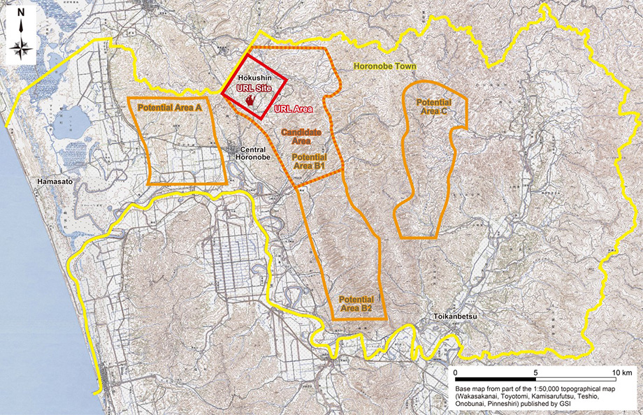
Modified from Ota, Abe and Kunimaru (2011)
Development of techniques for characterisation of geological environment from surface
Investigations were carried out stepwise from the surface in / around the URL area, which involved aerial / ground geophysical surveys to explore the geological structures and a series of borehole investigations to directly characterise the geological environment (Figure I-2). The key characteristics / properties and processes of importance in the context of geological disposal in host sedimentary rocks were captured in 2D or 3D site descriptive models (SDMs) at different spatial scales (Figure I-3). The applicability of the systematic techniques developed for stepwise surface-based investigations was demonstrated. A global integration methodology, ‘geosynthesis’, was incorporated into the site investigation techniques in an effective manner to integrate the site-specific information on the geological environment gained from different disciplines into consistent SDMs.
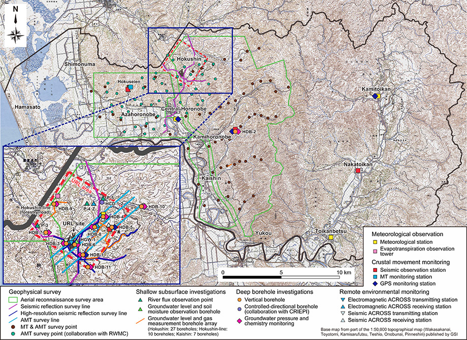
Modified from Ota, Abe and Kunimaru (2011)
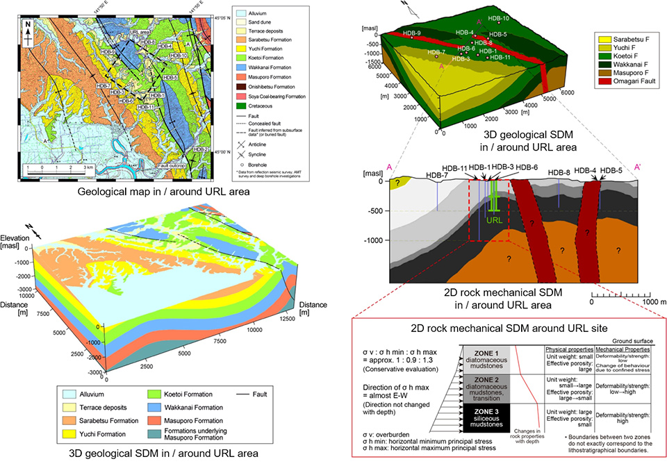
Modified from Ota, Abe and Kunimaru (2011)
Development of URL design / construction plans
On the basis of the information on the geological environment, which was obtained during the surface-based investigations, the technical specifications and layout of the URL were determined and its conceptual design and construction plans were then formulated so as to ensure the safe construction and maintenance of the URL (Figure I-4).
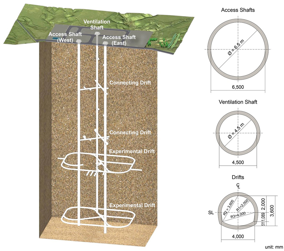
Ota, Abe and Kunimaru (2011)
Development of geological disposal technologies
Relevant technical knowledge was accumulated through case studies, which demonstrated, in particular, the applicability of the previously developed methods for repository design and safety assessments to the subsurface conditions observed during the surface-based investigations at Horonobe.
The details of the work and outcomes of the Phase I R&D are documented in JAEA Research 2010-068.
Phase II
(November 2005 to March 2015)
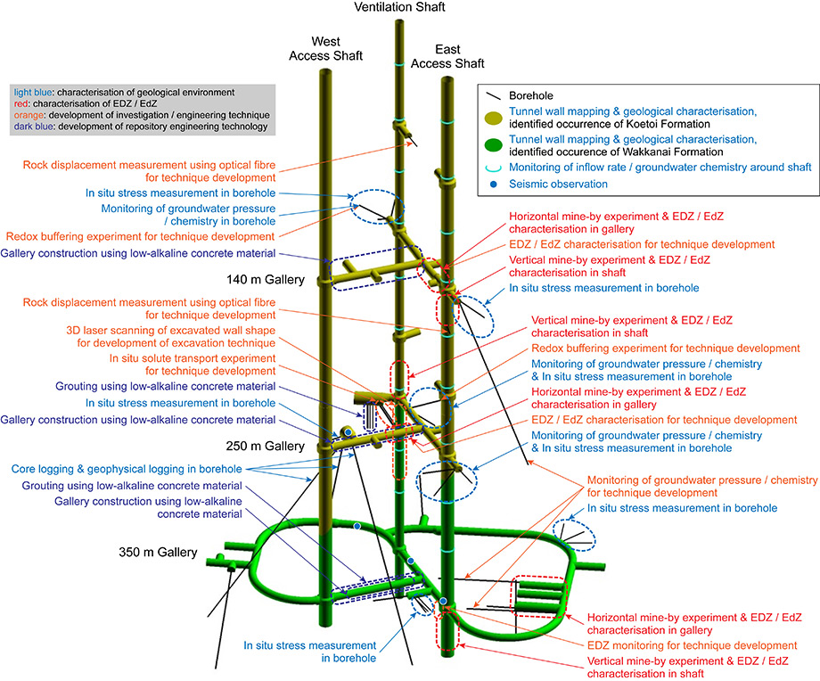
Development of techniques for characterisation of geological environment during tunnel excavation
Investigations were carried out during tunnel excavation (Figure II-1) and the results obtained were compared with the predictions based on the site descriptive models developed in Phase I. Good agreement between the two indicated that the reliability of the techniques for the surface-based investigations in Phase I and for the prediction of the impacts of URL construction on the geological environment was enhanced.
Development of techniques for understanding of long-term geosphere evolution
A desk study and site walk-over were continued from Phase I, which focussed in detail on the spatial / temporal sequences of natural events / processes occurred and their impacts on the geological environment in / around Horonobe (Figure II-2). A comprehensive methodology for understanding the palaeohydrogeological site evolution over very long periods of time was established. In addition, the impacts of seismic activities on the geological environment were understood.
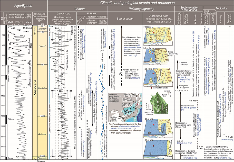
Niizato et al. (2010)
Development of engineering technologies for URL design / construction
The excavation of three shafts down to 350 metres below ground level (mbgl) and galleries at three levels were completed (Figure II-3). Prompt and accurate feedback of information on the geological environment allowed relevant engineering technologies to be developed in an effective manner; in particular, techniques for flexibly changing the design of the subsurface facilities and constructing the facilities, whilst appropriately taking countermeasures, when unexpected events were encountered or the potentially significant impacts of excavation-induced events on the geological environment were expected. Technical development was also promoted to ensure safety and maintain an appropriate in-tunnel environment during the URL construction / operation.
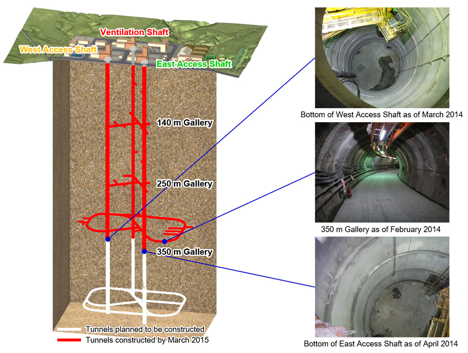
Left figure modified from Hama et al. (2016)
Development of geological disposal technologies
Low-alkaline concrete and grouting materials were developed and their applicability / workability were demonstrated in situ (Figure II-4). In addition, relevant knowledge on the properties and long-term behaviour of engineered barrier system (EBS) materials under saline conditions was accumulated. The safety assessment methodologies were progressively advanced through improving the quality / quantity of data required for repository safety assessments, testing underlying models and accumulating technical knowledge, which were of relevance, in particular, to groundwater flow and solute transport analyses.
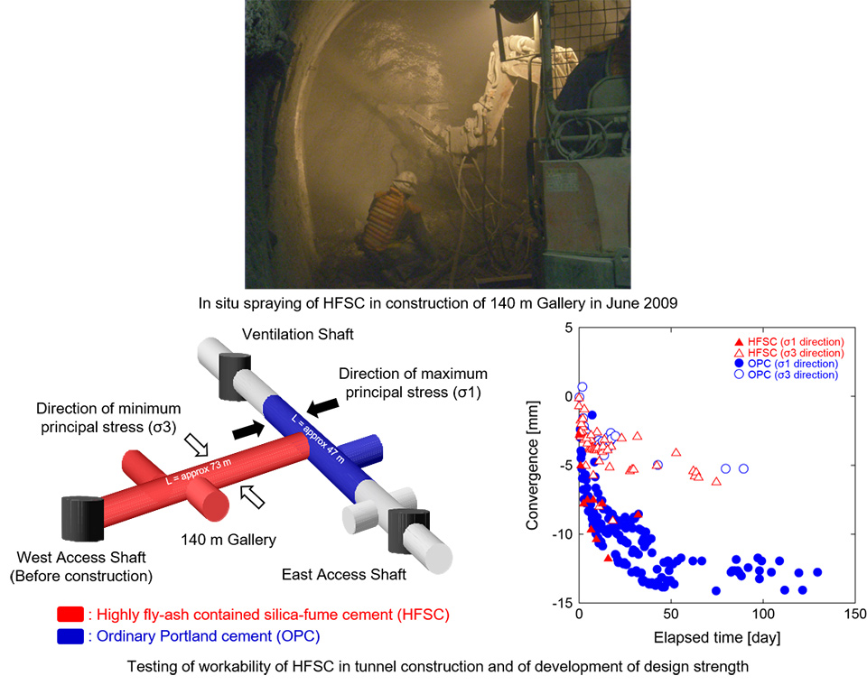
Bottom figures modified from Nakayama et al. (2010)
The details of the work and outcomes of the Phase II R&D are summarised in JAEA CoolRep H26.