


"Visualization" of radioactive contamination at the decommissioning site on a 3D map
—Understanding invisible radioactive contamination in a virtual space and reducing worker exposure—
An accurate understanding of the distribution of contamination due to radioactive substances is an important consideration during decontamination work at the Tokyo Electric Power Company Holdings, Incorporated (hereafter, “TEPCO”) Fukushima Daiichi Nuclear Power Station (hereafter, “1F”) in order to reduce radiation exposure and ensure that decontamination is conducted effectively.
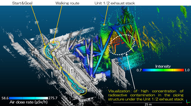
There are a lot of equipment and rubble that are contaminated at 1F, and a method for identifying contaminated locations in a 3D manner was needed in order to gain a more accurate understanding of distribution of radioactive contamination. Yet conventional methods using survey meters and gamma-ray imagers were more suited for spot locations or surfaces, and are difficult to use for identifying 3D contamination distribution.
In response to site requirements like this, the Japan Atomic Energy Agency developed the integrated Radiation Imaging System (iRIS) for visualizing contaminated locations and air dose rate by combining a Compton camera that is used for visualization of radioactive substances, survey meter, and a 3D image recognition device that uses a laser light.
It was used to demonstrate map imaging that visualized contamination distribution around the exhaust stacks of 1F units 1 and 2 as well as the dose rate distribution around walking access routes, where measurement time took less than 5 minutes without having to approach contaminated areas.
The 3D maps visualizing the contamination distribution and dose rate distribution can be projected in virtual spaces as part of simulations for shielding that reduces dose rates or to understand the effects of decontamination. The system is anticipated to be used by TEPCO and affiliated companies, and also used to help reduce radiation exposure of 1F decontamination workers.