Monitoring technology development
About this activity
A large amount of radioactive material was released from Fukushima Daiichi Nuclear Power Plant (FDNPP) into the environment and some of it was deposited on land owing to the accident in March 2011. To evaluate the deposition status and the air dose rate distribution owing to the FDNPP accident, a national project so-called Fukushima mapping project have been conducted since June 2011 by Japan Atomic Energy Agency (JAEA) and related organizations under commission from the Ministry of Education, Culture, Sports, Science and Technology (it is the Nuclear Regulation Authority behind). From 2011 to 2017, Sector of Fukushima Research and Development of JAEA had coordinated this project. By reorganization on April 1, 2018, “Monitoring Technology Development Group” was established in Nuclear Emergency Assistance and Training Center (NEAT) of JAEA in order to oversee the project.
Investigations on distribution of radioactive substances owing to the FDNPP accident
In the project, we have been conducting extensive researches on a) air dose rates and b) soil deposition distribution of radioactive materials using several different measurement methods.
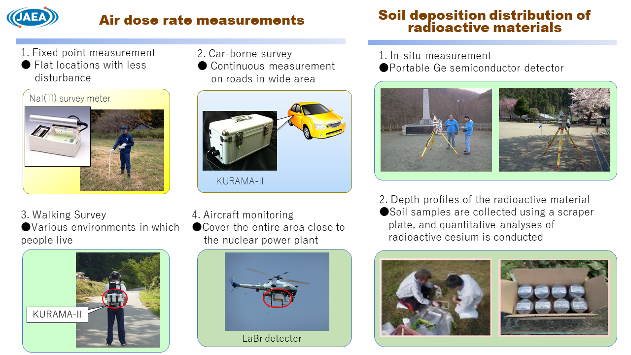
a) Air dose rates
Four types of measurement with different characteristic have been carried out in the measurement of the air dose rate to cover different type of environmental status.
1. Fixed point measurement
Air dose rates in flat and unpaved locations with less disturbance (about 6,500 sites) have been measured in the area of 80 km range from the FDNPP. Although the measurements are spatially discrete, the typical air dose rates representing the surrounding environment can be obtained in each location because the measurements are performed in the places where the environmental condition is similar each other.
2. Car-borne survey
Areas to be measured are limited on the road, but it is possible to acquire huge amount of data for a wide range.
3. Walking survey
Measurement range is limited, but there are features such as the ability to acquire the air dose rate in various environments in which people live, and to investigate the detail of the change in the air dose rate depending on the place.
4. Aircraft monitoring
It is difficult to evaluate detailed change in the air dose rate on the ground because the measurement is performed from the sky, but it has big advantages such that it can cover the entire measurement area including close to the FDNPP.
b) Soil deposition distribution of radioactive materials
“In-situ” measurements (on-site measurement) have been conducted at about 380 locations within 80 km of FDNPP using portable germanium semiconductor detectors to evaluate deposition density on the soil ground.
Another measurement on depth profiles of the radioactive material have been performed at 85 locations within 100 km of FDNPP. Soil samples are collected using a "scraper plate", and quantitative analyses of radioactive cesium in the samples are conducted.
Outcome summary of the Fukushima mapping project
The distribution situation and the change over time of air dose rate and radioactive substances due to the FDNPP accident were evaluated, and the characteristic of transition of radioactive cesium in the environment has been revealed. Some of the outcomes from the project are follows:
-
The air dose rate within the area of 80 km from the FDNPP has decreased considerably as compared to immediately after the accident. In particular, the air dose rate due to radioactive cesium in the human living environment has decreased to about 1/10 in six years from June 2011. In addition to the decrease due to the physical decay of radioactive cesium, environmental effect such as the shielding effect due to penetration into the ground, weathering effect and decontamination is the cause of the decrease in the air dose rate. (see the link [1])
- Knowledge and data obtained in relation to the project have been disclosed in various forms. Among them are information dissemination by publication of research papers in academic journals, by release of air dose rate distribution maps and detailed numerical database on a WEB page. (See the links [2] & [3])
Link